


 TFT Touchscreen 246 g Black")
 TFT Touchscreen 246 g Black")
 TFT Touchscreen 246 g Black")
 TFT Touchscreen 246 g Black")
 TFT Touchscreen 246 g Black")
The product's shade and actual color may differ from what is shown in the picture, as the images are for illustrative purposes. The product description is general and may not include all the product's features.
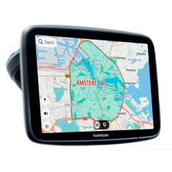
Garmin Tread Overland - Edition navigator Handheld/Fixed 20.3 cm (8") TFT Touchscreen 246 g Black
1 359,00 €
Monthly payment from 35.89 €
4176827 010-02508-10
0753759277574
Goods will arrive at the Tallinn warehouse on 08.04.26
You are interested in this product?
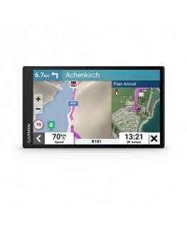
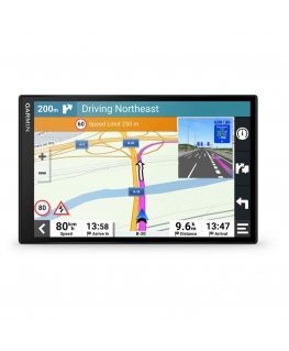
Built for every part of the journey, this rugged all-terrain sat nav has the mapping you need to stay on track and communication technology to stay in touch while you’re out there.
OFF-ROAD RUGGEDNESS
Purpose-built for all-terrain use, this Tread device stands up to anything the elements can throw at it. It’s IP67-rated for water-resistance.
HIGH-VISIBILITY DISPLAY
With its ultrabright 8″ glove-friendly touchscreen, the sat nav is designed for easy viewing in bright sunlight or pitch dark. It can be mounted in portrait or landscape mode.
TRAIL NAVIGATION
Enjoy turn-by-turn trail navigation1 for traversing unpaved roads and trails using adventure roads and trails map content comprised of OSM.
BUILT-IN INREACH TECHNOLOGY
Built-in inReach technology offers global satellite communication, two-way text messaging, location sharing, interactive SOS and weather updates.
MAPS ON AND OFF-ROAD
Tread features preloaded topographic maps with 3D terrain and streets maps for Europe, Africa including Tracks4Africa and Middle East. It also includes detailed street maps of Europe with custom routing for the size and weight of your rig2. North and South America, Australia and New Zealand.
SATELLITE IMAGERY
Enjoy vivid aerial views when you download high-resolution BirdsEye Satellite Imagery directly to your device via Wi-Fi connectivity, with no annual subscription required.
POINTS OF INTEREST
Tread comes preloaded with iOverlander points of interest, ACSI, Campercontact and Trailer’s PARK so you don’t need a mobile phone signal to route to the best-established, wild and dispersed campsites.
ABC SENSORS
When you’re headed to tough-terrain, the built-in sensors will come in handy — including an altimeter, barometer, compass and pitch/roll gauges.
SECURE MOUNT
Use the included locking magnet-assisted mount to secure the sat nav to your vehicle.
GROUP RIDE MOBILE
Pair your device with the Tread app to track your friends from your phone using the Group Ride Mobile feature3.
EASY ROUTE PLANNER
Use the Tread app to easily plan routes with the same maps, vehicle profiles and route preferences that you have on the Tread device.
EASILY SYNC YOUR DEVICES
Use the Tread app to sync waypoints, tracks, routes and collections across all your devices. Easily import and share GPX files, too.
LIVE WEATHER
Weather ahead? Pair your Tread device with your compatible smartphone, and download the Tread app to access live weather, storm alerts, animated radar and more.
GROUP RIDE TRACKER
Pair your device with the compatible Group Ride Tracker (sold separately) for group tracking5 and pre-defined messaging.
TRACK YOUR DOG PACK
Wirelessly pair Tread with select Garmin GPS dog trackers (sold separately) to help track and retrieve your sporting dogs in the field. You’ll see markers for each dog within tracking range, overlaid right on the sat nav’s map screen.
GPS type | |
| Outdoor (hiking, trekking) | Yes |
| Geocaching (GPS stash hunt) | Yes |
| Auto | Yes |
| Camper/Caravan | Yes |
| Motorcycle | Yes |
Map | |
| Ability to add maps | Yes |
| Maps included | Yes |
| Topographic map | Yes |
| Map view options | 2D/3D |
| Lifetime map updates | Yes |
Display | |
| Backlight display | Yes |
| Display resolution | 1280 x 800 pixels |
| Display | TFT |
| Display size (HxV) (imperial) | 4368.8 x 2692.4 mm (172 x 106") |
| Touchscreen | Yes |
| Display diagonal | 20.3 cm (8") |
| Touch technology | Multi-touch |
Memory | |
| Compatible memory cards | MicroSD (TransFlash) |
| Storage media type | Flash, Memory card |
| Internal storage capacity | 64 GB |
| Maximum memory card size | 256 GB |
Performance | |
| Audio formats supported | MP3 |
| MP3-player | Yes |
| Built-in camera | No |
| Smartphone/tablet remote support | Yes |
Design | |
| Form factor | Handheld/Fixed |
| Certification | MIL-STD-810 |
| Product colour | Black |
| International Protection (IP) code | IP6X |
| Water-resistant | Yes |
Power | |
| Battery life (max) | 6 h |
| Battery technology | Lithium-Ion (Li-Ion) |
| Power source type | Battery |
Weight & dimensions | |
| Weight | 246 g |
| Width | 205 mm |
| Depth | 30 mm |
| Height | 170 mm |
Packaging content | |
| Quick start guide | Yes |
| Cables included | USB Type-C |
Navigation | |
| Barometric altimeter | Yes |
| Electronic compass | Yes |
| Traffic Message Channel (TMC) | Yes |
| 3D landmarks | Yes |
| Speed limits | Yes |
| Photo navigation | Yes |
| Lane guidance | Yes |
| Live service | Yes |
Network | |
| Bluetooth | Yes |
| Wi-Fi | Yes |
| Bluetooth profiles | GNSS |
| Bluetooth Low Energy (BLE) | Yes |
GPS Performance | |
| Antenna | External |
30 other products in the same category: